Network Pulse
Every natural event our monitoring has flagged near a submarine cable - newest first. Each entry shows what happened and whether our latency measurements detected any impact.
M4.7 earthquake · 49 km NW of Yonakuni, Japan
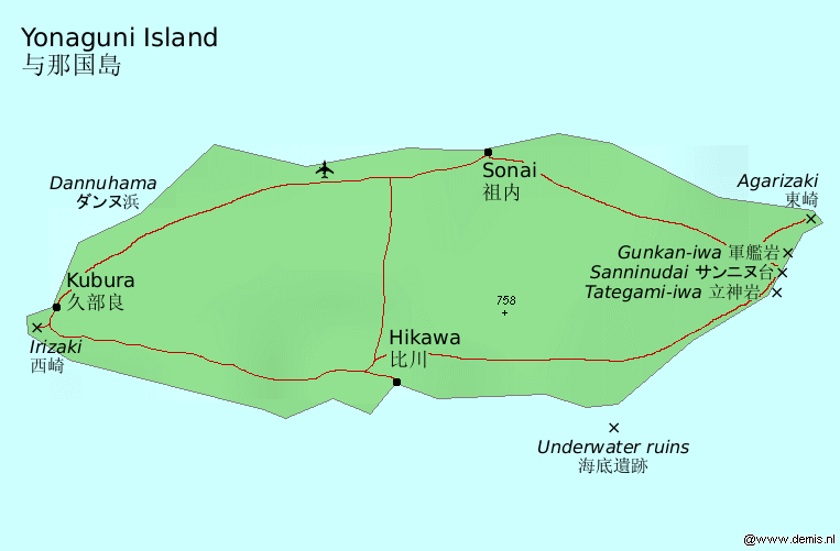
On July 2, 2026, a M4.7 earthquake occurred approximately 49 km northwest of Yonakuni, Japan.
The affected submarine cables with landing points within 350km include the Apricot, Asia Pacific Gateway (APG), FLAG North Asia Loop/REACH North Asia Loop, and New Cross Pacific cable systems, all landing at Toucheng, Taiwan. Our latency measurements indicate that these cables are currently experiencing average latencies of around 164ms to 55ms with a check frequency of 7 to 9 times per week. No active alerts have been triggered as of the latest monitoring data.
M5.2 earthquake · 23 km SSE of Karpathos, Greece

On July 2, 2026, a M5.2 earthquake struck approximately 23 km southeast of Karpathos, Greece. Our monitoring currently indicates no active alerts but has detected three latency anomalies.
The following submarine cables have landing points within 350km of the epicenter: Thetis, SeaMeWe-5, Thetis Express, Apollo East and West, 2Africa, EMC West-1, and India Europe Xpress (IEX). Latency measurements for these cables are as follows: Thetis (average 138ms), SeaMeWe-5 (148ms), Thetis Express (133ms), Apollo East and West (133ms), 2Africa (254ms), EMC West-1 (124ms), and IEX (137ms). These measurements reflect the current network status without any reported damage or outages.
M4.5 earthquake · 88 km WSW of Gorontalo, Indonesia

On July 2, 2026, a magnitude 4.5 earthquake occurred approximately 88 km southwest of Gorontalo, Indonesia.
- The affected area includes the Asia Connect Cable-1 (ACC-1) and Bifrost cables, which both land at Manado, Indonesia, located about 313 km from the epicenter. Our latency measurements indicate that ACC-1 has an average latency of ~222ms with 118 checks per week, while Bifrost shows an average latency of ~245ms with only 10 checks per week.
M6 earthquake · 49 km E of Noda, Japan
On July 1, 2026, a magnitude 6 earthquake occurred approximately 49 km east of Noda, Japan.
The submarine cable system affected is the Hokkaido-Sakhalin Cable System (HSCS), which has a landing point at Ishikari, Japan, located about 346 km from the epicenter. Our monitoring shows that this event resulted in latency anomalies on the HSCS, with an average measured latency increase of approximately 345 milliseconds over seven days. Currently, there are no active alerts on our network for this region.
M4.8 earthquake · 10 km WSW of Hyūga, Japan
On July 1, 2026, a magnitude 4.8 earthquake occurred approximately 10 km west-southwest of Hyūga, Japan.
The Korea-Japan Cable Network (KJCN), which lands at Kitakyushu, Japan, is within the affected region. Our monitoring shows that this cable experienced an average latency increase of about 37 milliseconds over seven days, with a total of 8 checks conducted. No active alerts were triggered by this event.
M6 earthquake · 75 km SSW of El Progreso, Mexico
On June 30, 2026, a magnitude 6 earthquake struck approximately 75 km SSW of El Progreso, Mexico.
No submarine cables with landing points within 350km of the epicenter are currently monitored by GeoCables. Our latency monitoring for the affected region has identified two latency anomalies, but no active alerts have been triggered as a result of this event. The absence of direct connections in the area means that we do not expect any immediate impact on our network services.
M4.6 earthquake · 221 km NNE of Bitung, Indonesia

A magnitude 4.6 earthquake occurred on June 30, 2026, approximately 221 km NNE of Bitung, Indonesia.
Our monitoring indicates that submarine cables in the vicinity have shown latency anomalies. Specifically, SEA-US (landing at Kauditan, Indonesia, 232km from the event), ACC-1 and Bifrost (both landing at Manado, Indonesia, 233km from the event), and IGG System (also landing at Manado) are within our monitored range. The latency for SEA-US is measured at an average of ~208ms with 10 checks per week, while ACC-1 and Bifrost show averages of ~221ms and ~233ms respectively, both with 121 checks per week. The IGG System shows a lower average latency of ~40ms with only 3 checks per week.
M4.8 earthquake · 46 km E of Noda, Japan

A magnitude 4.8 earthquake occurred on June 30, 2026, approximately 46 km east of Noda, Japan.
Our monitoring indicates that the Hokkaido-Sakhalin Cable System (HSCS), which lands at Ishikari, Japan, about 346 km from the epicenter, experienced a latency anomaly. The average latency for this cable was measured at approximately 345 milliseconds over seven days, with ten checks conducted. No active alerts were triggered by this event.
M4.9 earthquake · 234 km SSW of ‘Ohonua, Tonga

On June 29, 2026, a magnitude 4.9 earthquake struck approximately 234 km southwest of ‘Ohonua, Tonga.
No submarine cables with landing points within 350 km of the epicenter are currently monitored by our network. Our latency monitoring has detected two anomalies but no active alerts on the network, indicating that there is no reported impact to the submarine cable systems in this region at present.
M4.6 earthquake · 27 km N of Caraballeda, Venezuela
On June 29, 2026, a M4.6 earthquake struck approximately 27 km north of Caraballeda, Venezuela. Our monitoring currently shows no active alerts but has identified two latency anomalies on the network.
The affected submarine cables within 350km include ALBA-1 (landing at La Guaira), GlobeNet (at Maiquetia), and South American Crossing (SAC) (at Puerto Viejo). Latency measurements indicate that ALBA-1 has an average latency of about 157ms with 26 checks over seven days, GlobeNet shows around 108ms with 11 checks, and SAC measures approximately 98ms with 5 checks. The Amerigo Vespucci and Jerry Newton cables, located further from the epicenter, show no significant latency changes.
M5.3 earthquake · 35 km SSW of Cordova, Alaska

On June 29, 2026, a M5.3 earthquake struck approximately 35 km SSW of Cordova, Alaska. Currently, no submarine cables with landing points within 350km of this epicenter are catalogued in our monitoring system.
Our latency measurements indicate that three anomalies have been detected on the network as a result of this seismic activity. However, it is important to note that we do not have any confirmed reports of active alerts related to specific submarine cables in the affected region at present. The exact impact on the cables remains unknown until further analysis can be conducted.
M5 earthquake · 173 km S of Lembar, Indonesia

On June 29, 2026, a magnitude 5 earthquake occurred approximately 173 km south of Lembar, Indonesia.
The affected region includes the Indonesia Tengah Cable System, which has a landing point at Sanur, Indonesia, located about 202 km from the epicenter. Our latency measurements indicate an average delay of around 144 milliseconds with seven checks over seven days. Currently, there are no active alerts on our network, but we continue to monitor for any potential impacts.