Christiansted, Virgin Islands (U.S.)
Landing Point · VI Virgin Islands (U.S.)
Connected Cables
| Cable | Status |
|---|---|
| St. Thomas-St. Croix System | Active |
Live Performance
RTT measurements to this landing point from 2026-06-30 through 2026-09-07 - live ICMP round-trip time via our monitoring probes. Recomputed daily. ✓ No anomalies detected in the monitored period.
Measurement sources
| Probe | Location | Samples | Avg |
|---|---|---|---|
| #6410 own probe | Sao Paulo BR | 7 | 176.8 ms |
| #6427 own probe | Sydney AU | 7 | 179.3 ms |
| #1014473 own probe | Minsk BY | 7 | 170.7 ms |
| #6487 own probe | Singapore SG | 5 | 211.1 ms |
| #12541 | control probe | 4 | 114.0 ms |
| #61048 | control probe | 4 | 103.6 ms |
| #1015563 own probe | Saint Petersburg RU | 4 | 168.4 ms |
| #1016031 own probe | Kyiv UA | 4 | 172.8 ms |
| #1016653 | control probe | 3 | 103.0 ms |
| #62911 | control probe | 1 | 94.9 ms |
| #1014589 own probe | Almaty KZ | 1 | 237.1 ms |
About Christiansted, Virgin Islands (U.S.)
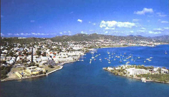
Christiansted, Virgin Islands (U.S.): Submarine Cable Landing Point
Christiansted is the largest town on Saint Croix, one of the main islands of the United States Virgin Islands. As a coastal settlement on an island territory, it serves as a landing point for submarine cable infrastructure connecting the islands of the U.S. Virgin Islands. One submarine cable lands at Christiansted, the St. Thomas-St. Croix System, which links landing points within the U.S. Virgin Islands and represents an inter-island connectivity corridor rather than an intercontinental route.
The St. Thomas-St. Croix System, which entered service in 1997, was among the earliest submarine cable deployments in the U.S. Virgin Islands. Its presence at Christiansted reflects the need to provide direct undersea connectivity between the island of Saint Croix and the broader island network of the territory.
Cables Landing at Christiansted, Virgin Islands (U.S.)
The St. Thomas-St. Croix System is a 183-kilometer submarine cable with a ready-for-service date of 1997. Both of its endpoints are located within the U.S. Virgin Islands, making it a purely intra-territorial cable. The system connects landing points across the islands of the U.S. Virgin Islands, with Christiansted on Saint Croix serving as one terminus of this inter-island link.
Regional Context
Within the U.S. Virgin Islands, which counts ten submarine cable landing points in total, Christiansted sits among a group of single-cable landing points that includes Banana Bay, Brewer's Bay, Butler Bay, and Flamingo Bay, each hosting one cable. The territory's most connected landing point is St. Croix, Virgin Islands, which hosts five cables, while Great Bay hosts two. Christiansted's single-cable profile places it in the majority tier of the territory's landing point landscape.
Network Role
Christiansted functions as a single-cable terminus within the U.S. Virgin Islands submarine cable network. Its sole cable, the St. Thomas-St. Croix System, provides an inter-island connection rather than a link to any external country, positioning Christiansted as a locally oriented endpoint rather than a hub for wider regional or intercontinental traffic. The cable it hosts was one of the first to enter service in the territory, with an RFS year of 1997 matching the earliest recorded deployment across the U.S. Virgin Islands as a whole.
Within the regional submarine cable graph of the U.S. Virgin Islands, Christiansted on Saint Croix represents one of several dedicated inter-island connection points that together complement the more heavily cabled hubs, underscoring the distributed nature of the territory's approach to maintaining undersea connectivity across its island chain.
What next: Christiansted, Virgin Islands (U.S.) in the global directory of cable landing points; see surrounding routes on the interactive submarine cable map or follow live network monitoring.
Other Landing Points in Virgin Islands (U.S.)
Landing Point
- CountryVI Virgin Islands (U.S.)
- Coordinates17.7467°N 64.7032°W
- Connected Cables1
See Real Cable Routes
View actual submarine cable routing from Christiansted, Virgin Islands (U.S.) - with backbone nodes, distance calculations, and latency estimates
Open Calculator →